


Files
Download Data (515.4 MB)
Download AIBG_Marker_Info_Sylvester_Manor_GPR.xlsx (9 KB)
Download AIBG_Markers_Photos_Info_Sylvester_Manor_GPR.xlsx (14 KB)
Download AIBG_dat.zip (95.5 MB)
Download AIBG_GPRTransects_Sylvester_Manor_GPR.zip (10 KB)
Download AIBG_Trees_and_Rocks_Sylvester_Manor_GPR.zip (98 KB)
Download AIBG_Marker_Photos_Sylvester_Manor_GPR.zip (1493.3 MB)
Author ORCID Identifier
0000-0002-4222-1544, 0009-0007-5432-355X
Publication Date
2026
Keywords
Sylvester Manor, Historical Archaeology, Ground Penetrating Radar
Disciplines
Archaeological Anthropology | United States History
Description
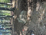
Survey data from the ground penetrating radar (GPR) survey at the Afro-Indigenous Burial Ground (AIBG) at Sylvester Manor, Shelter Island, NY. Zip folder contains raw recorded data (radargrams). Additional files include zipped shapefiles for GPR transects, trees and rocks; and dat file. Fieldstone marker files include zipped folders with an excel sheet listing numbered fieldstone markers, and a sheet listing the photographs of the fieldstone markers. Fieldstone marker number allows tor joining the photographs, and the "rock" shapefile to the list of markers.
The .rd7 files are the type generated by MALA GPR systems to record raw data (they are unprocessed binary data files containing the recorded electrical signals), along with .cor (coordinate data), .mrk (markers on radargrams), .mrkj (modern version of .mrk), and .rad (header file; contains survey parameters, antenna frequency, samples per trace, time window, and velocity) files. These are all needed to work with the raw GPR data.
Each shapefile is comprised of seven different file types: .CPG, .dbf, .prj, .sbn, .shp, .shx, and a .sbx file and all are needed for the shapefiles to function. The .shp files are the main files that store the actual spatial data (points, lines, or polygons). The other files contain character encoding (.CPG), shape attributes (.dbf), projection/coordinate system information (.prj), spatial index information for queries (.sbn, .shx, .sbx).
Description of Marker Database
Markers 1-161 are the original markers mapped in 2021 (Cultural Resource Management Study No. 89). Markers 210 and higher were mapped in 2025, and many are in the surrounding 2025 excavations. The shapefile of the rocks has several maker numbers appended with letters demarking that these rocks have been moved between field seasons. The two Excel tables for markers share common marker numbers for a one-to-many relationship.
Grant/Award Number and Agency
Mellon Foundation Grant to support the historic Manor House renovation and expanded History & Heritage Department programming and staffing.
Creative Commons License

This work is licensed under a Creative Commons Attribution 4.0 International License.
Recommended Citation
Steinberg, John M.; Schoenfelder, John; Lee, Nedra; Mrozowski, Stephen; Torrini, Chiara M.; Ostoyich, Tess; Ross, Claire; Delatour, Kristen; and Kinney, Joseph E., "Afro-Indigenous Burial Ground GPR Survey Data from UMass Boston Archaeological Work, Shelter Island, NY" (2026). Data and Datasets. 9.
https://scholarworks.umb.edu/data/9
Comments
Free and open access to this work is made available to the UMass Boston community by ScholarWorks at UMass Boston. Those not on campus and those without a UMass Boston campus username and password may gain access to this work through Interlibrary Loan. If you have a UMass Boston campus username and password and would like to download this work from off-campus, click on the “Off-Campus Users” button.