


-

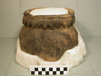
Artifact Catalog from Sylvester Manor UMass Boston Archaeological Work, Shelter Island, NY
Christa M. Beranek, Stephen Mrozowski, David B. Landon, Nedra Lee, John M. Steinberg, John Schoenfelder, Chiara M. Torrini, and Joseph E. Kinney
Artifact catalog from Sylvester Manor archaeological work (1998-2025) as of May 2026. The Artifact_List.rtf is a text file listed by unit and context. Artifact_Table.xlsx is the same data, but in tabular form. Unit_Contexts.xlsx is a table listing all the contexts by unit.
Artifact_Table and Artifact_List are very large files.
-

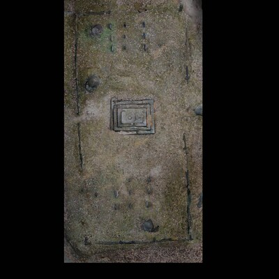
Family Cemetery GPR Survey Data from Sylvester Manor UMass Boston Archaeological Work, Shelter Island, NY
John M. Steinberg, John Schoenfelder, Stephen Mrozowski, Nedra Lee, Chiara M. Torrini, Tess Ostoyich, Claire Ross, and Joseph E. Kinney
The .rd7 files are the type generated by MALA GPR systems to record raw data (they are unprocessed binary data files containing the recorded electrical signals), along with .cor (coordinate data), .mrk (markers on radargrams), .mrkj (modern version of .mrk), and .rad (header file; contains survey parameters, antenna frequency, samples per trace, time window, and velocity) files. The info.dat file was derived from GPR-Slice. It is a critical ASCII text file that maps the GPR radargram filenames to their specific spatial positions. It defines the survey grid layout, including line lengths, survey direction (X or Y), and profile spacing. These are all needed to work with the raw GPR data.
Each shapefile is comprised of seven different file types: .CPG, .dbf, .prj, .sbn, .shp, .shx, and a .sbx file and all are needed for the shapefiles to function. The .shp files are the main files that store the actual spatial data (points, lines, or polygons). The other files contain character encoding (.CPG), shape attributes (.dbf), projection/coordinate system information (.prj), spatial index information for queries (.sbn, .shx, .sbx).
-

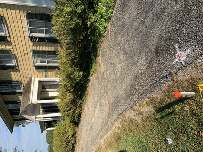
Datums and Benchmarks from Sylvester Manor UMass Boston Archaeological Work, Shelter Island, NY
John M. Steinberg, John Schoenfelder, Chiara M. Torrini, Joseph E. Kinney, Stephen A. Mrozowski, and David B. Landon
Datums from Sylvester Manor Archaeological work (2019-2026). Includes zipped shapefile of points and complementary csv, that includes the site areas for each datum.
-

Datum Reference Photos from Sylvester Manor UMass Boston Archaeological Work, Shelter Island, NY
John M. Steinberg, John Schoenfelder, Chiara M. Torrini, Joseph E. Kinney, Stephen Mrozowski, David B. Landon, and Nedra Lee
Photographs of site datums used during UMass Boston archaeological work at Sylvester Manor. File names contain the datum name followed by a sequential number. Each datum contains a set of multiple photographs showing its location at a near and far scale, illustrating its exact spot and place in the broader landscape, respectively. Some datums have photographs showing how the survey rod needs to be placed, and some have images that include a pin flag with the datum name written on it. Includes zipped folder.
-

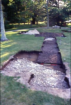
Excavation Units from Sylvester Manor UMass Boston Archaeological Work, Shelter Island, NY
John M. Steinberg, John Schoenfelder, Chiara M. Torrini, Joseph E. Kinney, Stephen Mrozowski, David B. Landon, and Nedra Lee
Excavation units from Sylvester Manor archaeological work (1998-2025). Includes zipped polygon shapefile with outlines of excavation units.
-

Shovel Test Pits from Sylvester Manor UMass Boston Archaeological Work, Shelter Island, NY
John M. Steinberg, John Schoenfelder, Chiara M. Torrini, Joseph E. Kinney, Stephen Mrozowski, David B. Landon, and Nedra Lee
Shovel test pits (STPs) from Sylvester Manor archaeological work (1998-2025). STPs were excavated as 50cm-x-50cm squares and sometimes expanded into larger excavations. These points typically represent the southwest corner of test pits but not always. See shapefile metadata for more information. Includes zipped point shapefile with points each representing one corner of a STP.
-

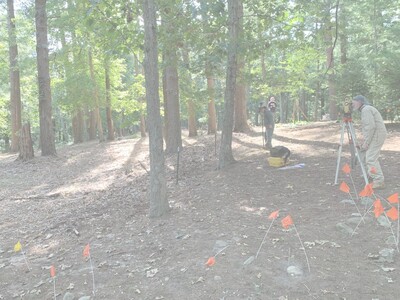
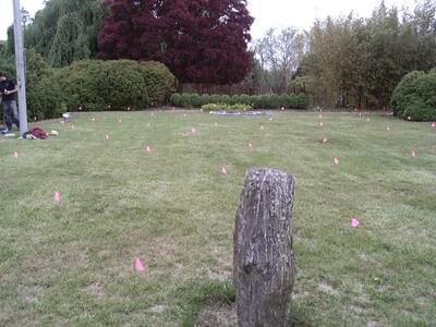
Report on the 2021 Archaeological mapping at the Potential Afro-Indigenous Burial Ground on the Sylvester Manor Educational Farm, Shelter Island, New York
John M. Steinberg, John W. Schoenfelder, Stephen A. Mrozowski, Heather B. Trigg, and Nedra Lee
This report describes the scope and preliminary results of the archaeological mapping undertaken at the potential Afro-Indigenous Burial Ground on Sylvester Manor by the Fiske Center for Archaeological Research from the University of Massachusetts Boston in October of 2021 for the Sylvester Manor Educational Farm (SMEF). The data collection was prompted by Groundskeeper Gunnar Wisseman’s observation of a number of fieldstones that appeared on the surface of the area around the potential Afro-Indigenous Burial Ground. These stones were identified during and after a cleanup of the area. Because the SFEF master plan draft gives primacy to the potential Afro-Indigenous Burial Ground, the fieldstones were mapped, in anticipation of further work, which might include shovel test pits, excavation, and geophysical prospection.
As part of the 2021 work, 8 semi-permanent datums-or benchmarks-were established. With the datums established, over 4,500 individual topographic points were taken during the project using total station setups based on these 8 benchmarks. As part of the topographic mapping, 48 trees and 170 rocks were recorded, each with 3-8 individual topographic points taken. Around the potential Afro-Indigenous Burial Ground, the lower elevations were about 5 m above sea level (asl), and the highest points were 16.4 m asl. The surface stones do not seem to be clustered together or be randomly scattered but rather evenly spaced across the demarcated area.
Printing is not supported at the primary Gallery Thumbnail page. Please first navigate to a specific Image before printing.